Photogrammetry & DEMs
Precise Digital Elevation Models (DEMs) are the source for many applications. We automatise processing chains (e.g. automatic image selection, GCP identification) for DEM generation from various sources. We optimise matching algorithms, pre- and postprocessing (e.g. contrast enhancements, elimination of sensor variations, outlier filtering, gap filling). Our advanced methods are based both on physically- and deep-learning-based models.
Surface Stability & Changes
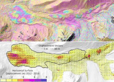
Many processes impact stability of the Earth surface and objects. We develop multi-methods, -sensor and -scale approaches to monitor surface stability and changes. The methods include DEM differencing, Interferometric SAR, Persistent Scatter Interferometry and feature/speckle tracking. The methods are developed with different very-high-resolution remote sensing data and calibrated and validated by GNSS and close-range remote sensing measurements.
Machine Learning
Machine learning has shown huge potential in many fields including remote sensing. We optimise deep-learning frameworks together with object-based image analysis (OBIA) for image classification and object detection. Moreover, we use machine learning for model optimisation. We focus besides Random Forest on the classical U-Net which has a CNN architecture for semantic segregation and newer models such as the transformer model Swin model.
Cryosphere
The cryosphere is an important source of water and impacts natural hazards but is strongly affected by climate change. We are monitoring the changes in area, volume, mass and velocity of glaciers and rock glaciers using various remote sensing data and techniques. Our remote-sensing based investigations are complemented by modelling and regular field investigations. Our regional foci are the Austrian Alps and High Mountain Asia.
Mountain Hazards
Natural hazards like rock falls, landslides and mud flows are common in mountain areas. Glacial lake outburst floods are a common threat in many glacierised mountains. We are developing approaches to holistically identify and monitor hazardous prone areas and potentially dangerous glacial lakes. We investigate stability of the terrain, tigger mechanisms and identify potentially impacted areas by applying different satellite-based and close-rage remote sensing methods and modelling.
Cultural Heritage Documentation
Our documentations includes buildings, monuments, archaeological sites and landscapes. We use GNSS, UAV acquisitions, laser scanning, terrestrial and aerial photogrammetry and other (geophysical prospecting) methods. Typical products are 3D models with textures and orthophotos. We also specialize in emergency recording where fast response is essential, e.g. due to buildings being demolished.
Tobias Bolch
Steyrergasse 30/I
8010 Graz
Austria
Tel: +43 (316) 873 - 6848
Fax: +43 (316) 873 -6337
tobias.bolch@tugraz.at